A air quality alert in effect for 6 regions in the area
See the complete list

We continue to follow the progress of Invest 93L, an area of low pressure that moved from the Atlantic across the northern Florida peninsula on Tuesday and is now scraping westward through the state’s panhandle along the northern Gulf Coast.

After storms brought flooding on Monday, cities prepared for the possibility of more waterlogged streets on Tuesday.

So far in 2025, National Weather Service offices have issued more flood warnings than any other year on record dating back to 1986.

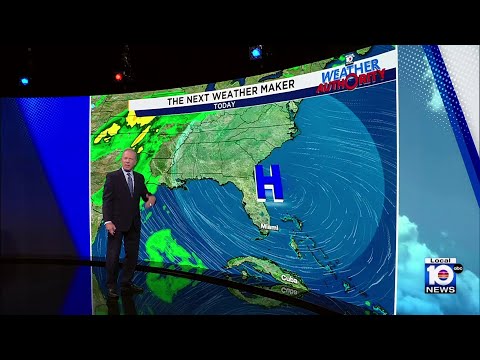
A disturbance that emerged off the coastal Carolinas on Sunday is expected to swing across Florida and into the Gulf by mid-week, where models suggest it could slowly develop as it scrapes across the northern Gulf Coast.

A Flood Watch has been issued Monday for Miami-Dade and Broward counties.

Big outbreaks of Saharan dust – tens of millions of tons of mineral dust hoisted from the sands of North Africa into the Atlantic each hurricane season – typically peak around this time each year.

On Wednesday, some of the nation’s top hurricane scientists joined House Democrats for a virtual press conference to sound the alarm on proposed budget cuts that would severely degrade hurricane monitoring and forecasting.

Forecasters at Colorado State University – the pioneers of seasonal hurricane forecasting – issued their July outlook for the hurricane season, nudging down numbers from their April and June outlooks, but still calling for a slightly above average season overall.

July is a transition month in the Atlantic when we begin to look a little deeper into the basin and closer to Africa for hurricane seedlings.

The catastrophic flooding that ripped through parts of the Texas Hill Country along the Guadalupe River northwest of San Antonio during the predawn hours on July 4th quickly turned into an unspeakable tragedy, killing at least 82 people, including 28 children.
Tropical Storm Chantal crept closer to the South Carolina coast Saturday evening, prompting expanded tropical storm warnings and raising concerns about flash flooding, heavy rainfall and gusty winds across parts of the Carolinas through the end of the weekend.

Showers and thunderstorms are becoming more concentrated around an area of low pressure – now designated Invest 92L – centered about 100 miles off the coast of northeast Florida.

Most of South Florida is waking up to warm, muggy conditions this Fourth of July, and while rain may soak some midday parades and barbecues, meteorologists say skies should clear in time for the fireworks.

A combination of weather features, including a stalled front and developing area of low pressure off northeast Florida, have turned on the holiday tap, directing rounds of tropically-infused storms toward the Florida peninsula beginning today and extending into the holiday weekend.

We continue to monitor a weakening cold front now over the southeast U.S. that’s expected to stall over Florida by late week and could spin off a tropical depression or named storm by the weekend or early next week.

Only days after the U.S. Department of Defense abruptly announced the immediate termination of satellite data critical to hurricane forecasts – granted a moratorium early Monday through July – NOAA posted details of its 2026 budget request to Congress.
As darkness descended on the Gulf of Mexico in October, a 1970s-era U.S. government turboprop plane neared the eye of the newly formed Hurricane Milton.

A stalled front across Florida’s peninsula later this week could spawn a tropical system over the northeastern Gulf or off the Southeast U.S. by the Fourth of July weekend.

An area of disturbed weather moving through the western Caribbean is expected to cross into the Bay of Campeche in the lower reaches of the Gulf this weekend where it could gradually organize if the system remains over the waters north of Mexico.

On Monday, the U.S. Department of Defense announced it would immediately stop ingesting, processing, and transmitting data essential to most hurricane forecasts.

The low-level cloud swirl spinning harmlessly over the open waters of the high Atlantic wasn’t much to look at on Tuesday but managed to muster up enough steam for NHC to briefly classify it Tropical Storm Andrea, the first named storm of the 2025 hurricane season.

It’s been 219 days since we’ve seen a tropical depression or named storm anywhere in the Atlantic, but it looks like that streak will end on Tuesday.

After its most sluggish start to a hurricane season since 2014, the Atlantic is threatening to break its silence with a short-lived system over the open waters of the subtropical Atlantic.
South Florida has officially entered the summer season, but if you’ve been outside lately, you already know it’s felt like summer for months.

July is a unique month in the Atlantic hurricane season. It can be a forgiving month for the U.S., a month when storms begin to form farther away, temporarily lessening the risk closer to home.
As South Florida marks Juneteenth with parades, barbecues and community events, forecasters are urging residents to keep an umbrella nearby — especially in inland areas.

Erick became the second hurricane of the eastern Pacific hurricane season early Wednesday and is forecast to rapidly strengthen before striking southwest Mexico on Thursday as a dangerous Category 2 or Category 3 hurricane.

It appears the Atlantic will stay storm free through week three of the hurricane season, with no development expected in the week ahead.

As we’ve written in previous newsletters, the Atlantic’s seen several early season Saharan dust outbreaks, some of which have reached our skies stateside in South Florida. But exactly how unusual have the dust outbreaks been?

As we discussed in the daily newsletter last Thursday, the tropical Atlantic has undergone a major cooldown so far in 2025, from unprecedented warmth in 2023 and 2024 to now near-average conditions across the Atlantic Main Development Region or MDR.

Any homeowner that’s been through a flood knows that once is once too many. But for Brian Martin and his family, flooding has been a way of life since moving to the waterfront neighborhood of Shores Acres along the western edge of Tampa Bay.

His voice was labored, weathered from overuse, as he relived the hellish hours of a world crashing in around him six months earlier.
With no development expected in the Atlantic this week, the daily newsletter will devote time to sharing stories and lessons learned from survivors of the 2024 hurricane season.

South Florida residents and visitors can expect hazy skies and sweltering heat this weekend, as another surge of Saharan dust drifts across the region, keeping tropical development at bay but pushing air quality and humidity levels higher.

It’s been a dusty start to the 2025 hurricane season with the biggest Saharan dust outbreak of the year reaching the sands of South Florida this week from the soils of West Africa over 4,000 miles away.

To start last hurricane season, waters across the Atlantic Main Development Region or MDR – where most of our strongest hurricanes form during the peak months of the hurricane season – were experiencing chart-topping warmth.

In early June, we don’t have to look very far from our coastlines to find tropical troublemakers.

A Flood Watch has been canceled for Miami-Dade and Broward counties.

On Monday afternoon, the National Hurricane Center outlined its first area of interest of the young hurricane season off the Carolina coast.

A Flood Watch has been issued for most of South Florida through Wednesday morning.

A surge of tropical moisture set the stage for the severe weather in South Florida that prompted the Federal Aviation Administration to temporarily stop flights and flooded some roads on Monday afternoon.

It’s the opening week of the 183-day Atlantic hurricane season, which runs from June 1 through Nov. 30. The good news right off the bat: no development is expected for the first full week of the season.

Sunday is the first day of this year’s hurricane season, and the first since the administrations of President Donald Trump and Gov. Ron DeSantis changed the government’s response.
The hurricane season started Sunday with strong thunderstorms rumbling through South Florida due to tropical moisture.

A large tree is blocking the roadway at 620 East Tropical Way in Plantation, prompting police to urge drivers to find alternate routes Saturday afternoon.

Clouds are building across South Florida as a stalled front is expected to bring multiple rounds of thunderstorms across the region on Saturday afternoon, prompting residents and visitors to adjust their outdoor plans heading into the weekend.

The 2025 hurricane season began Sunday, and Local 10 is making sure you are prepared.

Stay prepared for the Atlantic Hurricane Season with the Local 10 Weather Authority’s 2025 Hurricane Survival Guide in English and en Español.
A male worker was injured Saturday at Fort Lauderdale Executive Airport while helping upright a small plane flipped by storm that caused widespread damage across southern Broward County on Friday, authorities confirmed.

After a chaotic round of severe storms Friday, calmer skies returned to South Florida on Saturday morning — but forecasters warn the reprieve may not last through the day.

Cleanup efforts are underway in Miramar on Saturday after a fast-moving storm with powerful winds and hail ripped through the area overnight, leaving residents without power and with significant property damage.

Government forecasters issued their first outlook for the upcoming 2025 hurricane season on Thursday.

Two retired hurricane experts are sounding the alarm over proposed federal budget cuts that they say could seriously undermine the accuracy of hurricane forecasts and put coastal communities at greater risk this storm season.

Several areas of Miami-Dade County were impacted by heavy rain and flooding on Monday.

Steady rain and stormy conditions rolled into Hollywood and much of South Florida on Monday morning, prompting concerns about flooding, strong wind gusts and hazardous driving conditions.

A flood watch was in effect for Miami-Dade and Broward counties as heavy rain and strong storms drenched much of South Florida Monday morning, creating hazardous travel conditions and raising concerns of flash flooding.

A potentially drought busting rainfall is on the way to South Florida Monday and Tuesday.

A large tree narrowly missed a home in South Miami when it fell during Sunday’s storms, but it did crush a brand new car.

It will be a soggy Cinco De Mayo Monday as much of South Florida is under a marginal risk for severe thunderstorms.

A flood advisory was issued for parts of South Florida on Sunday.

Local 10 is examining a potential public safety alert regarding how DOGE staffing cuts to NOAA and the National Weather Service may already be impacting the ability of federal meteorologists to accurately forecast approaching storms.

A cold front moving across South Florida brought waves of heavy rain Tuesday, triggering a flood advisory for parts of Broward County and creating hazardous conditions on the roads during the afternoon commute.

The Florida Senate has passed a bill banning weather manipulation.

On Thursday, the pioneers of seasonal hurricane forecasts released their first predictions of what the upcoming Atlantic hurricane season could hold.

South Florida sky watchers will have the chance to witness a total lunar eclipse early Friday morning, as Earth’s shadow completely covers the moon.
A tornado touched down Monday in Seminole County, collapsing a home in Longwood and overturning a tractor-trailer in Lake Mary, WKMG in Orlando reported.

A smoky haze blanketed parts of Broward County on Thursday as winds carried smoke from a wildfire burning near Lake Okeechobee into South Florida, prompting concern among residents and visitors.

The abrupt termination of several National Oceanic and Atmospheric Administration employees, including experienced hurricane modelers, has sparked concerns among experts about the agency’s ability to provide accurate storm forecasts.

As Arctic air grips much of the nation, the stage is set for South Florida’s heat streak to end.

After 25 consecutive days of no measurable rain, Miami received .51 inches of rain on Tuesday, while Fort Lauderdale received .03 inches.

A weak cold front made its way through South Florida on Monday, bringing slightly cooler temperatures and a refreshing breeze across the region.

Love isn’t the only thing in the air this Valentine’s Day — so are heat and humidity, as South Florida remains locked in an extended warm spell with no sign of cooler temperatures ahead.

Florida Gov. Ron DeSantis is set to hold a press conference Tuesday morning in Tallahassee as freezing temperatures affect northern parts of the state.
Protecting your home from natural disasters is essential, and one of the most effective ways to do so is by installing impact-resistant windows.

After South Florida shivered through a rare cold snap, temperatures are rebounding quickly.

Temperatures dropped even lower overnight, with lows in the 40s, which is the coldest air the Miami area has felt since January 2023.

You know it’s winter in South Florida when you see people out in sweaters and shorts.

The coldest air of the winter season so far invades South Florida midweek.

A cold front is heading down the state of Florida. It won’t arrive until later Monday, so highs across South Florida will warm up to the 80s during the day.

Roller coaster weather continues in South Florida as we climb to the middle 70s to end out the weekend.

South Florida residents, brace yourselves — while a brief glimpse of 80-degree weather is on the horizon, a significant cold snap is set to follow.

South Florida residents woke up Tuesday to dense fog on the final day of 2024, prompting a dense fog advisory for Broward, Miami-Dade, and surrounding areas until 10 a.m.

South Florida residents and visitors can expect warm and mostly dry conditions on Thursday, with highs reaching 80 degrees, several degrees above average for this time of year.

A powerful winter storm is disrupting holiday travel across large swaths of the United States this Christmas Eve, blanketing states from Massachusetts to Wisconsin, Michigan, and New York in snow.

On Christmas Eve, South Floridians preparing for Nochebuena festivities — complete with lechón and family gatherings — are keeping a close eye on the forecast as moisture builds in the atmosphere, signaling rainier days ahead.

South Florida residents and visitors are waking up to a crisp and comfortable Monday morning as temperatures in Miami and Fort Lauderdale hover in the mid-60s, signaling a pleasant start to the holiday week.

Severe weather in Broward County brought torrential downpours and flooding to Fort Lauderdale and surrounding areas Wednesday, leading to traffic disruptions and stalled vehicles.

South Floridians can expect another active weather day on Wednesday as a new weather pattern takes hold, bringing a mix of heat, humidity, and frequent rain showers.

Lows are in the 50s degrees on Wednesday morning in South Florida, where there will be another dry day with highs only reaching the low 70s.

The Local 10 Weather Authority app has gotten a makeover just as South Florida is beginning to feel a chill in the air!

Folks in South Florida are urged to bundle up yet again as lows were in the 50s Tuesday morning.

With Thanksgiving just around the corner, South Floridians can look forward to seasonally warm and dry weather, perfect for outdoor festivities and travel.

South Florida residents and visitors are expected to enjoy refreshing temperatures as Thanksgiving week begins, with cooler air keeping the region cozy.

Be ready to bundle up as skies are clear Friday and a chilly change has arrived with lows dropping to the 50s across South Florida.

Grab your rain gear -- all eyes are on the big chill headed our way by Friday. A strong cold front will bring a better chance for storms Wednesday before the coldest air of the season arrives by Friday.

Residents and visitors across South Florida are embracing a refreshing change in the weather as cooler temperatures bring a touch of autumn to the region.
South Florida residents are bracing for changing weather this week as the remnants of Tropical Storm Sara, now a moisture-laden system, merge with an advancing cold front.

An Arctic front is coming to South Florida before Thanksgiving and not before Christmas.
