We continue to follow the progress of Invest 93L, an area of low pressure that moved from the Atlantic across the northern Florida peninsula on Tuesday and is now scraping westward through the state’s panhandle along the northern Gulf Coast.
So far in 2025, National Weather Service offices have issued more flood warnings than any other year on record dating back to 1986.
A disturbance that emerged off the coastal Carolinas on Sunday is expected to swing across Florida and into the Gulf by mid-week, where models suggest it could slowly develop as it scrapes across the northern Gulf Coast.
Big outbreaks of Saharan dust – tens of millions of tons of mineral dust hoisted from the sands of North Africa into the Atlantic each hurricane season – typically peak around this time each year.
On Wednesday, some of the nation’s top hurricane scientists joined House Democrats for a virtual press conference to sound the alarm on proposed budget cuts that would severely degrade hurricane monitoring and forecasting.
July is a transition month in the Atlantic when we begin to look a little deeper into the basin and closer to Africa for hurricane seedlings.
The catastrophic flooding that ripped through parts of the Texas Hill Country along the Guadalupe River northwest of San Antonio during the predawn hours on July 4th quickly turned into an unspeakable tragedy, killing at least 82 people, including 28 children.
We continue to monitor a weakening cold front now over the southeast U.S. that’s expected to stall over Florida by late week and could spin off a tropical depression or named storm by the weekend or early next week.
Only days after the U.S. Department of Defense abruptly announced the immediate termination of satellite data critical to hurricane forecasts – granted a moratorium early Monday through July – NOAA posted details of its 2026 budget request to Congress.
A stalled front across Florida’s peninsula later this week could spawn a tropical system over the northeastern Gulf or off the Southeast U.S. by the Fourth of July weekend.
On Monday, the U.S. Department of Defense announced it would immediately stop ingesting, processing, and transmitting data essential to most hurricane forecasts.
The low-level cloud swirl spinning harmlessly over the open waters of the high Atlantic wasn’t much to look at on Tuesday but managed to muster up enough steam for NHC to briefly classify it Tropical Storm Andrea, the first named storm of the 2025 hurricane season.
After its most sluggish start to a hurricane season since 2014, the Atlantic is threatening to break its silence with a short-lived system over the open waters of the subtropical Atlantic.
July is a unique month in the Atlantic hurricane season. It can be a forgiving month for the U.S., a month when storms begin to form farther away, temporarily lessening the risk closer to home.
In less than 24 hours, Erick rapidly strengthened from a 65 mph tropical storm to a potentially catastrophic 145 mph Category 4 hurricane as it neared Mexico’s southwest coastline between Acapulco and Puerto Escondido.
Erick became the second hurricane of the eastern Pacific hurricane season early Wednesday and is forecast to rapidly strengthen before striking southwest Mexico on Thursday as a dangerous Category 2 or Category 3 hurricane.
It appears the Atlantic will stay storm free through week three of the hurricane season, with no development expected in the week ahead.
As we’ve written in previous newsletters, the Atlantic’s seen several early season Saharan dust outbreaks, some of which have reached our skies stateside in South Florida. But exactly how unusual have the dust outbreaks been?
As we discussed in the daily newsletter last Thursday, the tropical Atlantic has undergone a major cooldown so far in 2025, from unprecedented warmth in 2023 and 2024 to now near-average conditions across the Atlantic Main Development Region or MDR.
Any homeowner that’s been through a flood knows that once is once too many. But for Brian Martin and his family, flooding has been a way of life since moving to the waterfront neighborhood of Shores Acres along the western edge of Tampa Bay.
His voice was labored, weathered from overuse, as he relived the hellish hours of a world crashing in around him six months earlier.
With no development expected in the Atlantic this week, the daily newsletter will devote time to sharing stories and lessons learned from survivors of the 2024 hurricane season.
The Atlantic hurricane season’s sluggish start will continue into the second week of the season, with no development expected through the work week.
It’s been a dusty start to the 2025 hurricane season with the biggest Saharan dust outbreak of the year reaching the sands of South Florida this week from the soils of West Africa over 4,000 miles away.
To start last hurricane season, waters across the Atlantic Main Development Region or MDR – where most of our strongest hurricanes form during the peak months of the hurricane season – were experiencing chart-topping warmth.
In early June, we don’t have to look very far from our coastlines to find tropical troublemakers.
On Monday afternoon, the National Hurricane Center outlined its first area of interest of the young hurricane season off the Carolina coast.
It’s the opening week of the 183-day Atlantic hurricane season, which runs from June 1 through Nov. 30. The good news right off the bat: no development is expected for the first full week of the season.
Government forecasters issued their first outlook for the upcoming 2025 hurricane season on Thursday.
On Thursday, the pioneers of seasonal hurricane forecasts released their first predictions of what the upcoming Atlantic hurricane season could hold.
Tropical Storm Sara formed Thursday afternoon just 50 miles east of Honduras, drifting slowly along the country’s northern coast on Friday, spreading torrential rainfall across not only Honduras, but through Belize, El Salvador, eastern Guatemala, western Nicaragua, and eastern portions of Mexico’s Yucatán Peninsula.
The disturbance we’ve been tracking through the Caribbean this week was upgraded to Tropical Depression Nineteen Thursday morning off the coast of northern Honduras.
A disturbance tracking south of Jamaica Wednesday morning – designated Invest 99L by the National Hurricane Center – is expected to organize into Tropical Storm Sara over the coming days and could strengthen into a powerful hurricane by this weekend as it hangs about off the coasts of Honduras and Nicaragua.
A significant late-season tropical system is poised to come together later this week and could strengthen into a formidable November hurricane by this weekend or early next week as it meanders in the western Caribbean.
With Rafael quickly spinning down over the Gulf of Mexico this weekend – its thunderstorm activity wiped clear by a slug of dry air and hostile wind shear – we’d hope the hurricane season would finally come to its senses and move into its traditional November hibernation, but the Caribbean has other plans.
Rafael re-strengthened overnight to a major Category 3 hurricane over the central Gulf of Mexico, becoming the farthest west a Category 3 or stronger hurricane has been observed during the month of November.
Rafael strengthened into a major Category 3 hurricane with 115 mph winds shortly before striking the southern coast of western Cuba at 4:15 PM ET Wednesday near Playa Majana in Artemisa Province.
On Sunday, the National Hurricane Center initiated advisories on Potential Tropical Cyclone Eighteen, a tropical disturbance in the southwestern Caribbean forecast to develop into a named storm in the coming hours, possibly reaching hurricane status before impacting western Cuba by Wednesday.
The next storm in the Atlantic is likely to spin up over the weekend or early next week out of the Central American Gyre, or CAG, the semi-permanent, sprawling area of spin that straddles the land areas separating the eastern Pacific and the Caribbean Sea on the Atlantic side -- the same feature responsible for so many of our devastating hurricanes in 2024 -- including the likes of Milton and Helene.
Overnight computer models waffled on the outlook for a disturbance we’ve been following in the southwestern and central Caribbean, softening its development prospects and pushing back the development window into early next week.
As we detailed a week ago in this newsletter, the Caribbean is expected to make another run at tropical development later this week or into the weekend as we turn the calendar to November.
After a banner start to October that included 3 simultaneous hurricanes (Kirk, Leslie, and Milton) during its first week – a first in our record books for the month of October – with more activity packed into one month than we see in some Augusts and Septembers (traditionally our busiest months) combined, including the strongest hurricane in almost two decades (Milton), a devastating Florida hurricane hit and a surprise hurricane (Oscar) – the smallest we’ve ever measured – last weekend, the tropics are finally simmering down to end the month.
Since official Atlantic tropical cyclone recordkeeping began some 174 years ago, nearly 600 tropical storms or hurricanes have struck the mainland U.S. shoreline during all months of the year, except for January, March, April and December. Of those landfalling storms, only about a dozen struck during the month of November.
After taking a slow, horseshoe-shaped dip across eastern Cuba over the past 36 hours and dumping over a foot of heavy rain – causing pockets of significant flooding – poorly-organized Oscar is picking up the pace and accelerating through the southeastern Bahamas and toward the western Atlantic.
It’s not often we see a colossal failure in hurricane forecasting, but over the weekend the sudden formation of Hurricane Oscar on Saturday near the Turks and Caicos off the southeastern Bahamas was a reminder why we watch every system carefully, especially those close to land during the peak months of the hurricane season.
Two disturbances we’ve been tracking this week – one in the western Caribbean and the other passing just north of Puerto Rico and the U.S. Virgin Islands today – will bring the threat of heavy rainfall to Central America and the Greater Antilles but neither will be a concern for the mainland U.S.
After its most active start to October on record and following a spate of 5 hurricanes – including 3 major hurricanes – in less than 2 weeks, the Atlantic is throttling back to a more reasonable pace for middle October.
Back around the traditional ramp up to the hurricane season peak in early September, lots was written about the hurricane season “bust” – alluding to what forecasters predicted to be one of the busiest hurricane seasons on record.
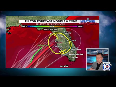
Only days after explosively strengthening into the most intense Gulf hurricane in nearly two decades, the eye of Hurricane Milton crossed west-central Florida’s coastline at Siesta Key near Sarasota – just 20 miles south of Tampa Bay – as a Category 3 hurricane with 120 mph winds around 8:30 p.m. local time Wednesday evening.
Hurricane Milton rapidly intensified Monday morning into a dangerous major hurricane over the southern Gulf of Mexico and is on track to deliver yet another devastating blow to the Sunshine State less than two weeks after Hurricane Helene ravaged parts of Florida’s west coast and sweeping Big Bend.
Tropical Storm Milton, formed on Saturday and strengthened into a hurricane Sunday before accelerating towards Florida’s west coast on Monday and Tuesday into Wednesday.
Storm surge records shattered along Florida’s Gulf Coast, with hurricane gusts and flash flood emergencies sweeping inland across the southeastern U.S.
Gov. Ron DeSantis has declared a state of emergency for 41 counties, including Monroe County, as an organizing cluster of storms over the western Caribbean is expected to gradually develop into a named storm over the next day or two and could quickly strengthen into a formidable hurricane.
A broad area of low pressure near the coast of Nicaragua today is expected to slowly organize this week and is likely to become a tropical depression or named storm by the middle of the week as it heads northward toward the U.S. Gulf Coast for Thursday into Friday.
It’s been an unexpected and unusual hurricane season. The season has produced 4 hurricanes so far, about what’s typical through middle September, but certainly below what we would’ve expected given the conditions going into this season and the historic seasonal forecasts.
A tropical wave producing thunderstorms was strengthening on Saturday afternoon in the Caribbean, according to the National Hurricane Center Miami’s tropical weather outlook.
Hurricane Ernesto continued to churn northward toward Bermuda on Friday, with its large, outer circulation bringing gusty winds already nearing tropical storm strength to parts of the archipelago on Friday morning.
Tropical Storm Debby, which formed Saturday afternoon, continues to strengthen this morning and is expected to become a hurricane before making landfall in Florida’s Big Bend tomorrow. Conditions will quickly deteriorate today along Florida’s Gulf Coast, with up to 10 feet of storm surge flooding possible into many of the same areas affected by Hurricane Idalia last August.
In Wednesday morning’s newsletter, we discussed how the interplay between the robust tropical wave moving through the complex terrain of the northeastern Caribbean islands today and tomorrow would be crucial to its forecast this weekend.
Beginning last Wednesday we began previewing the possibility of development of a tropical disturbance nearing the Caribbean islands for this week and in Friday morning’s newsletter we discussed a more conducive configuration for development once the disturbance moves into the western Atlantic later this week.
In the modern hurricane record – since satellites came around in the 1960s – most Julys observe at least one named storm, but about 1 in 3 Julys come and go without any new named storms. Additionally, most Julys – nearly 70% – pass by without any new hurricane formations.
The disturbance formerly known as Invest 95L was classified a Potential Tropical Cyclone by the National Hurricane Center Sunday afternoon, which allowed the center to issue Tropical Storm Watches for Jamaica and Grand Cayman Island ahead of the organizing system.