We continue to follow the progress of Invest 93L, an area of low pressure that moved from the Atlantic across the northern Florida peninsula on Tuesday and is now scraping westward through the state’s panhandle along the northern Gulf Coast.
So far in 2025, National Weather Service offices have issued more flood warnings than any other year on record dating back to 1986.
Big outbreaks of Saharan dust – tens of millions of tons of mineral dust hoisted from the sands of North Africa into the Atlantic each hurricane season – typically peak around this time each year.
On Wednesday, some of the nation’s top hurricane scientists joined House Democrats for a virtual press conference to sound the alarm on proposed budget cuts that would severely degrade hurricane monitoring and forecasting.
Forecasters at Colorado State University – the pioneers of seasonal hurricane forecasting – issued their July outlook for the hurricane season, nudging down numbers from their April and June outlooks, but still calling for a slightly above average season overall.
July is a transition month in the Atlantic when we begin to look a little deeper into the basin and closer to Africa for hurricane seedlings.
Tropical Storm Chantal crept closer to the South Carolina coast Saturday evening, prompting expanded tropical storm warnings and raising concerns about flash flooding, heavy rainfall and gusty winds across parts of the Carolinas through the end of the weekend.
The National Hurricane Center announced on Friday afternoon that there was an Atlantic tropical depression gradually strengthening near Florida.
Showers and thunderstorms are becoming more concentrated around an area of low pressure – now designated Invest 92L – centered about 100 miles off the coast of northeast Florida.
A combination of weather features, including a stalled front and developing area of low pressure off northeast Florida, have turned on the holiday tap, directing rounds of tropically-infused storms toward the Florida peninsula beginning today and extending into the holiday weekend.
We continue to monitor a weakening cold front now over the southeast U.S. that’s expected to stall over Florida by late week and could spin off a tropical depression or named storm by the weekend or early next week.
Only days after the U.S. Department of Defense abruptly announced the immediate termination of satellite data critical to hurricane forecasts – granted a moratorium early Monday through July – NOAA posted details of its 2026 budget request to Congress.
As darkness descended on the Gulf of Mexico in October, a 1970s-era U.S. government turboprop plane neared the eye of the newly formed Hurricane Milton.
A stalled front across Florida’s peninsula later this week could spawn a tropical system over the northeastern Gulf or off the Southeast U.S. by the Fourth of July weekend.
An area of disturbed weather moving through the western Caribbean is expected to cross into the Bay of Campeche in the lower reaches of the Gulf this weekend where it could gradually organize if the system remains over the waters north of Mexico.
On Monday, the U.S. Department of Defense announced it would immediately stop ingesting, processing, and transmitting data essential to most hurricane forecasts.
The low-level cloud swirl spinning harmlessly over the open waters of the high Atlantic wasn’t much to look at on Tuesday but managed to muster up enough steam for NHC to briefly classify it Tropical Storm Andrea, the first named storm of the 2025 hurricane season.
It’s been 219 days since we’ve seen a tropical depression or named storm anywhere in the Atlantic, but it looks like that streak will end on Tuesday.
After its most sluggish start to a hurricane season since 2014, the Atlantic is threatening to break its silence with a short-lived system over the open waters of the subtropical Atlantic.
July is a unique month in the Atlantic hurricane season. It can be a forgiving month for the U.S., a month when storms begin to form farther away, temporarily lessening the risk closer to home.
In less than 24 hours, Erick rapidly strengthened from a 65 mph tropical storm to a potentially catastrophic 145 mph Category 4 hurricane as it neared Mexico’s southwest coastline between Acapulco and Puerto Escondido.
Erick became the second hurricane of the eastern Pacific hurricane season early Wednesday and is forecast to rapidly strengthen before striking southwest Mexico on Thursday as a dangerous Category 2 or Category 3 hurricane.
It appears the Atlantic will stay storm free through week three of the hurricane season, with no development expected in the week ahead.
As we’ve written in previous newsletters, the Atlantic’s seen several early season Saharan dust outbreaks, some of which have reached our skies stateside in South Florida. But exactly how unusual have the dust outbreaks been?
As we discussed in the daily newsletter last Thursday, the tropical Atlantic has undergone a major cooldown so far in 2025, from unprecedented warmth in 2023 and 2024 to now near-average conditions across the Atlantic Main Development Region or MDR.
Any homeowner that’s been through a flood knows that once is once too many. But for Brian Martin and his family, flooding has been a way of life since moving to the waterfront neighborhood of Shores Acres along the western edge of Tampa Bay.
His voice was labored, weathered from overuse, as he relived the hellish hours of a world crashing in around him six months earlier.
With no development expected in the Atlantic this week, the daily newsletter will devote time to sharing stories and lessons learned from survivors of the 2024 hurricane season.
The Atlantic hurricane season’s sluggish start will continue into the second week of the season, with no development expected through the work week.
It’s been a dusty start to the 2025 hurricane season with the biggest Saharan dust outbreak of the year reaching the sands of South Florida this week from the soils of West Africa over 4,000 miles away.
To start last hurricane season, waters across the Atlantic Main Development Region or MDR – where most of our strongest hurricanes form during the peak months of the hurricane season – were experiencing chart-topping warmth.
In early June, we don’t have to look very far from our coastlines to find tropical troublemakers.
On Monday afternoon, the National Hurricane Center outlined its first area of interest of the young hurricane season off the Carolina coast.
It’s the opening week of the 183-day Atlantic hurricane season, which runs from June 1 through Nov. 30. The good news right off the bat: no development is expected for the first full week of the season.
Sunday is the first day of this year’s hurricane season, and the first since the administrations of President Donald Trump and Gov. Ron DeSantis changed the government’s response.
The hurricane season started Sunday with strong thunderstorms rumbling through South Florida due to tropical moisture.
The 2025 hurricane season began Sunday, and Local 10 is making sure you are prepared.
Stay prepared for the Atlantic Hurricane Season with the Local 10 Weather Authority’s 2025 Hurricane Survival Guide in English and en Español.
Government forecasters issued their first outlook for the upcoming 2025 hurricane season on Thursday.
Two retired hurricane experts are sounding the alarm over proposed federal budget cuts that they say could seriously undermine the accuracy of hurricane forecasts and put coastal communities at greater risk this storm season.
Hurricane season begins June 1 and that means it’s time to start thinking about your disaster plans.
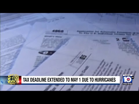
The IRS is giving individuals and businesses across Florida until May 1 to file various federal tax returns and make payments, following last year’s devastating Hurricane Milton.
On Thursday, the pioneers of seasonal hurricane forecasts released their first predictions of what the upcoming Atlantic hurricane season could hold.
Tropical Storm Sara formed Thursday afternoon just 50 miles east of Honduras, drifting slowly along the country’s northern coast on Friday, spreading torrential rainfall across not only Honduras, but through Belize, El Salvador, eastern Guatemala, western Nicaragua, and eastern portions of Mexico’s Yucatán Peninsula.
Sara, a tropical storm on Friday, was forecast to move into the Gulf of Mexico. It could start to merge into a cold front and move more east toward Florida.
The disturbance we’ve been tracking through the Caribbean this week was upgraded to Tropical Depression Nineteen Thursday morning off the coast of northern Honduras.
Tropical Depression 19 strengthened into Tropical Storm Sara Thursday afternoon in the western Caribbean. Life-threatening and potentially catastrophic flash flooding and mudslides are expected in Honduras through the weekend, the National Hurricane Center reported.
A disturbance tracking south of Jamaica Wednesday morning – designated Invest 99L by the National Hurricane Center – is expected to organize into Tropical Storm Sara over the coming days and could strengthen into a powerful hurricane by this weekend as it hangs about off the coasts of Honduras and Nicaragua.
A significant late-season tropical system is poised to come together later this week and could strengthen into a formidable November hurricane by this weekend or early next week as it meanders in the western Caribbean.
A significant late-season tropical system is poised to come together later this week and could strengthen into a formidable November hurricane by this weekend or early next week as it meanders in the western Caribbean.
With Rafael quickly spinning down over the Gulf of Mexico this weekend – its thunderstorm activity wiped clear by a slug of dry air and hostile wind shear – we’d hope the hurricane season would finally come to its senses and move into its traditional November hibernation, but the Caribbean has other plans.
Rafael re-strengthened overnight to a major Category 3 hurricane over the central Gulf of Mexico, becoming the farthest west a Category 3 or stronger hurricane has been observed during the month of November.
Rafael strengthened into a major Category 3 hurricane with 115 mph winds shortly before striking the southern coast of western Cuba at 4:15 PM ET Wednesday near Playa Majana in Artemisa Province.
Tropical Storm Rafael formed on Monday in the Caribbean – the 17th named storm of the busy 2024 Atlantic hurricane season – and is on track to impact the Cayman Islands on Tuesday and parts of western Cuba on Wednesday as a hurricane.
On Sunday, the National Hurricane Center initiated advisories on Potential Tropical Cyclone Eighteen, a tropical disturbance in the southwestern Caribbean forecast to develop into a named storm in the coming hours, possibly reaching hurricane status before impacting western Cuba by Wednesday.
The next storm in the Atlantic is likely to spin up over the weekend or early next week out of the Central American Gyre, or CAG, the semi-permanent, sprawling area of spin that straddles the land areas separating the eastern Pacific and the Caribbean Sea on the Atlantic side -- the same feature responsible for so many of our devastating hurricanes in 2024 -- including the likes of Milton and Helene.
As we first detailed in this newsletter last Thursday, a tropical depression or named storm could come together by this weekend or early next week as it meanders around in the central and western Caribbean.
Overnight computer models waffled on the outlook for a disturbance we’ve been following in the southwestern and central Caribbean, softening its development prospects and pushing back the development window into early next week.
As we detailed a week ago in this newsletter, the Caribbean is expected to make another run at tropical development later this week or into the weekend as we turn the calendar to November.
After a banner start to October that included 3 simultaneous hurricanes (Kirk, Leslie, and Milton) during its first week – a first in our record books for the month of October – with more activity packed into one month than we see in some Augusts and Septembers (traditionally our busiest months) combined, including the strongest hurricane in almost two decades (Milton), a devastating Florida hurricane hit and a surprise hurricane (Oscar) – the smallest we’ve ever measured – last weekend, the tropics are finally simmering down to end the month.
Since official Atlantic tropical cyclone recordkeeping began some 174 years ago, nearly 600 tropical storms or hurricanes have struck the mainland U.S. shoreline during all months of the year, except for January, March, April and December. Of those landfalling storms, only about a dozen struck during the month of November.
After taking a slow, horseshoe-shaped dip across eastern Cuba over the past 36 hours and dumping over a foot of heavy rain – causing pockets of significant flooding – poorly-organized Oscar is picking up the pace and accelerating through the southeastern Bahamas and toward the western Atlantic.
It’s not often we see a colossal failure in hurricane forecasting, but over the weekend the sudden formation of Hurricane Oscar on Saturday near the Turks and Caicos off the southeastern Bahamas was a reminder why we watch every system carefully, especially those close to land during the peak months of the hurricane season.
After forming in the western Caribbean, Tropical Storm Nadine was away from Florida and impacted Central America on Saturday.
Two disturbances we’ve been tracking this week – one in the western Caribbean and the other passing just north of Puerto Rico and the U.S. Virgin Islands today – will bring the threat of heavy rainfall to Central America and the Greater Antilles but neither will be a concern for the mainland U.S.
The story of Trooper, the dog that was found chained to a fence in flood waters as Hurricane Milton approached Florida, captured the hearts of many.
After its most active start to October on record and following a spate of 5 hurricanes – including 3 major hurricanes – in less than 2 weeks, the Atlantic is throttling back to a more reasonable pace for middle October.
South Florida crews have been sent to help our Florida neighbors on the west coast.
National Hurricane Center meteorologists in Miami reported Sunday afternoon that a well-defined area of low pressure could become the next tropical depression in the Atlantic.
After Hurricane Milton, Raphaela Williams pleaded for help for Charlotte County’s Little Gasparilla Island, a barrier island with a seven-mile beach. It’s only reachable by boat. Cars aren’t allowed, so residents drive golf carts over thin sandy pathways.
The National Weather Service released a survey Friday reporting that a Hurricane Milton-related tornado injured three people who took shelter in their homes on Wednesday in Glades County.
The National Weather Service released a survey Friday reporting that a Hurricane Milton-related tornado injured seven people and caused “considerable” structural damage in 30 minutes on Wednesday in Palm Beach County.
A tornado ravaged through the Spanish Lakes Country Club Village, a retirement community in St. Lucie County’s Lakewood Park neighborhood, and killed six residents.
Helene and Milton are two names many Floridians won’t soon forget as they recover from the major hurricanes, with many hoping to rebuild. But will the two major storms, coming essentially back-to-back, sink Florida’s property insurance market?
Residents in the Sarasota area are starting the process of evaluating the damage, again.
Some homes in the Tampa area have been cut off by flooding from Hurricane Milton.
There were tornadoes in Florida before Hurricane Milton even made landfall. One destroyed homes for miles Wednesday afternoon in Indian River County’s Vero Beach area. Mandy Reese said she was terrified when she realized one was closing in. She was home, grabbed her two kids, and ran into the bathroom — holding one on each side.
Back around the traditional ramp up to the hurricane season peak in early September, lots was written about the hurricane season “bust” – alluding to what forecasters predicted to be one of the busiest hurricane seasons on record.
Charities are asking for your help as Florida recovers from two devastating hurricanes.
Daylight revealed the damage and debris left behind from Hurricane Milton in a north Tampa neighborhood off Nebraska Avenue.
The dog found by a Florida Highway Patrol trooper during Hurricane Milton evacuations earlier this week in Tampa has been renamed “Trooper” and is now in foster care.
Severe weather brought on by Hurricane Milton spawned tornadoes that ripped through Palm Beach County. Wellington, just west of West Palm Beach, was hit hard.
Residents in the Tampa Bay area are surveying the damage left behind by Hurricane Milton.
Streets in the Upper Florida Keys are swamped with floodwaters as Hurricane Milton brought heavy storm surges and coastal flooding to the region.
Milton is the third hurricane to hit Florida this year, and it dumped record rain on the state.
North Fort Myers was one of the hardest-hit areas in Florida overnight, as a powerful storm surge and a tornado spawned by Hurricane Milton caused widespread destruction. Streets are now littered with debris, and homes in mobile home parks sustained significant damage.
A race is underway to rescue residents after Hurricane Milton plowed into the west coast of Florida as a powerful Cat. 3 storm.
A series of large, violent tornadoes spawned by Hurricane Milton hit the Spanish Lakes Country Club mobile home community in Fort Pierce Wednesday, causing significant destruction and four deaths.
As South Florida braces for the aftermath of Hurricanes Milton and Helene, the nonprofit organization Food For The Poor has sprung into action to support the region’s most vulnerable communities.
Only days after explosively strengthening into the most intense Gulf hurricane in nearly two decades, the eye of Hurricane Milton crossed west-central Florida’s coastline at Siesta Key near Sarasota – just 20 miles south of Tampa Bay – as a Category 3 hurricane with 120 mph winds around 8:30 p.m. local time Wednesday evening.
Hurricane Milton evacuees were bracing for the worst Thursday morning as many across Hillsborough County returned home to assess the damage.
An industrial dumpster ended up in a Palm Beach County home after a tornado moved through a neighborhood.
Powerful Hurricane Milton made landfall along Florida’s west coast Wednesday night as a strong Category 3 storm.
This year’s hurricane season has been challenging for roofers in South Florida.
As Hurricane Milton inches closer to Florida, Miami Beach residents and tourists are feeling the brunt of the storm’s powerful winds, while businesses along Ocean Drive cautiously remain open on Wednesday.
Hurricane Milton was only hours away from landfall Wednesday night in Florida’s Gulf Coast, and there were already reports of tornadoes.
Residents in flood prone areas of Broward County are already seeing standing water on some roads as the impact from Hurricane Milton begins to be felt in the area.
The Wind has been picking up in a very dicey Tampa Bay area as Hurricane Milton moves over land.
As evacuations related to Hurricane Milton continued Wednesday in Tampa, a Florida Highway Patrol trooper found a dog tied to a barbed wire fence pole in a grassy flooded area.